
676
FXUS65 KFGZ 010501
AFDFGZ

Area Forecast Discussion
National Weather Service Flagstaff AZ
1001 PM MST Mon Aug 31 2026

.SYNOPSIS...Scattered showers and thunderstorms will continue into
this evening, with drier conditions returning for the middle of
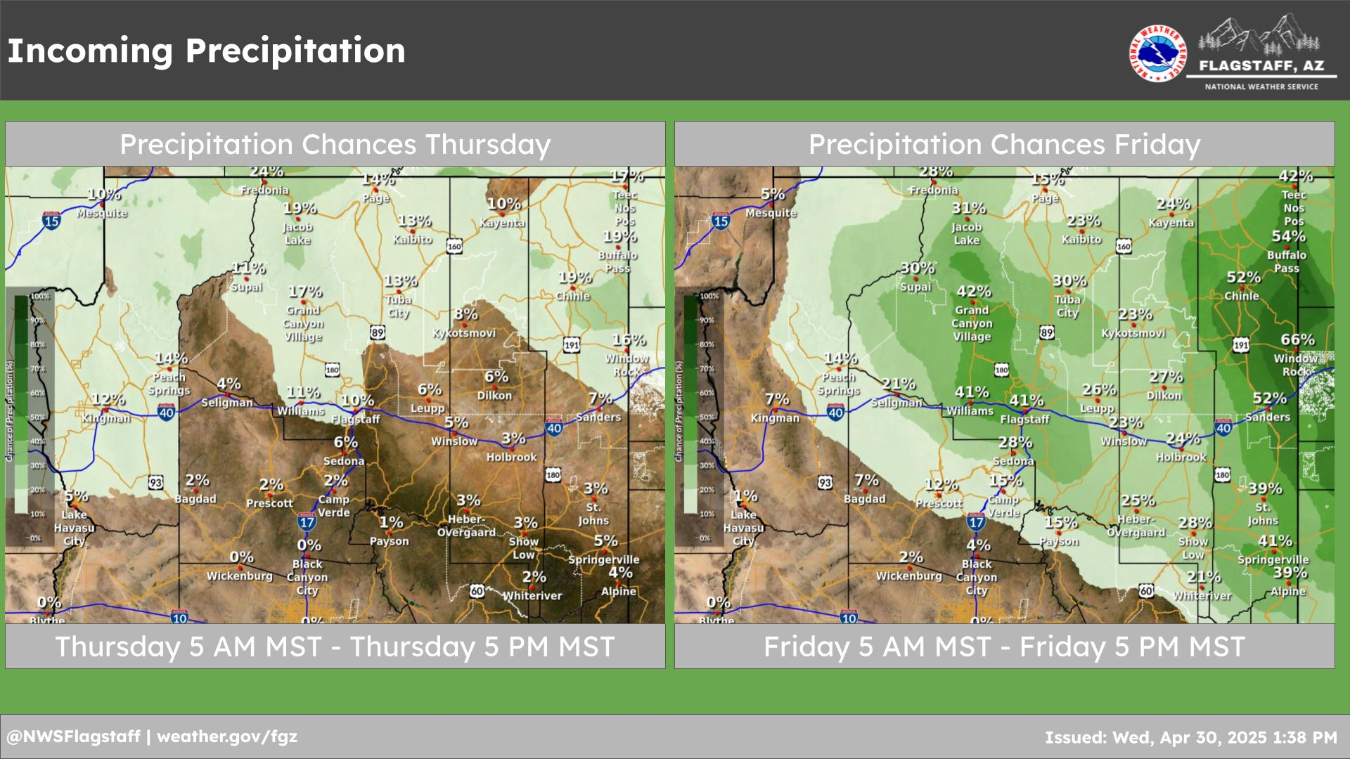
the week. Additional showers and thunderstorms are likely again by Friday
through the weekend.

&&

.DISCUSSION...A shortwave lifting northeastward ahead of the large
west coast trough is focusing convection in northwest Arizona up
into Utah early this afternoon. This area also started the day
sunny, so additional instability was able to build. This is where
the highest flash flood threat will be (north/west Coconino
County) into this evening, with WPC upgrading the area to a
moderate risk for flash flooding. Elsewhere, the large area of
showers and thunderstorms that moved northward through much of the
region left overnight behind a cooler and more stable boundary
layer with surface temperatures mostly in the 60s. So the threat
of stronger storms outside of north/west Coconino County has
lowered. However, with deep moisture in place and some
redevelopment still possible, will leave the Flash Flood Watch in
place into this evening. Tuesday through Thursday, southwest flow
aloft will increase as the western US trough moves closer,
bringing some drier air into our region but not completely
scouring out the low level moisture. As a result, there is still a
chance for some isolated showers and thunderstorms each afternoon,
but intensity appears to be less than what we have seen the last
several days. Daytime high temperatures will be a few degrees
below normal through the period. Southwest breezes will also
increase due to the trough, reaching 15-20 mph and gusting up to
30 mph at times.

Friday into the weekend - high pressure nudges back westward as
the west coast trough retreats a bit. This should allow for a more
southerly flow with moisture returning to the area. The timing of
the moisture return, and the influence of a possible tropical
system off the coast of Baja remain uncertain. This will impact
just how much moisture we end up seeing. For now, storm chances
rise to the 30-60% range for Friday through Sunday.

&&

.AVIATION...Tuesday 01/06Z through Wednesday 02/06Z...Mainly VFR
conditions expected. Isolated SHRA/TSRA near KPGA through 09Z, creating
localized areas of MVFR conditions. Gusty/erratic winds possible
near storms. Light and variable or terrain driven winds will turn
SW at 10-15 knots by Tuesday afternoon. Isolated SHRA/TSRA across
the higher terrain are expected to start around 18Z.

OUTLOOK...Wednesday 02/06Z through Friday 04/06Z...VFR conditions
expected. Look for SW winds 10-20 kts each afternoon, becoming
light and variable overnight. There will be a slight chance for
SHRA/TSRA each afternoon, with main impacts being gusty/erratic
winds.

&&

.FIRE WEATHER...Rest of today through Wednesday...Shower and
thunderstorm activity is mostly in northwestern Arizona today, while
a thick layer of clouds that was across most northern Arizona this
morning is helping to reduce day time heating and the development
of showers and thunderstorms. This cloud cover is expected to
decrease the evening and overnight, and should allow for isolated
showers and thunderstorms over the terrain on Tuesday. Heavy rain
leading to flash flooding, especially over recent burn scars, will
continue to be a main concern. Storms today will also be capable
of producing hail, gusty/erratic winds, and frequent lightning,
though this risk should decrease tonight through Wednesday.
Outside of storm driven winds, look for SW winds 5-15 mph today,
increasing to 10-20 mph Tuesday and Wednesday. Expect daytime
highs 5-15 degrees below normal.

Thursday through Saturday...A brief drying trend is expected to
continue into Thursday, although an isolated hi-based shower is not
out of the question. Friday and Saturday appears to be more active
across central/northern Arizona in terms of showers/storms.
Temperatures look to slowly warm through the period, becoming closer
to seasonal norms. Expect southwest winds 10-20 mph each afternoon,
becoming light and variable overnight.

&&

.FGZ WATCHES/WARNINGS/ADVISORIES...
Flood Watch until midnight MST /1 AM MDT/ tonight for AZZ004-005.

&&

$$

PUBLIC...JJ
AVIATION...Zanker
FIRE WEATHER...Schank

For Northern Arizona weather information visit
weather.gov/flagstaff
NWS Flagstaff Office



 Tucson, AZ


